Cartography, maps & plans of the catacombs and underground quarries
Cartography and maps of
CATACOMBES OF PARIS
2011
![]()
© explographies.com
Maps, Artworks,
Texts, copyrighted
.
All rights reserved - Reproduction, Publication & Saleare strictly forbidden
.
![]()
![]()
![]()
![]()
![]()
![]()
![]()
![]()
![]()
![]()
![]()
![]()
Conception, realisation, maps and documents :
- nexus -
Translation : Lisa Hale & Sylvain Margaine
other links : explographies. - cube project - carbide-lamps - igc maps - catacombs & quarries - photos - atlas 1855- - geology - minimal-cube - k-room - geopedia
![]()
![]()
![]()
history of catacombs & exploration maps
___________________________________________________________
exploration maps of catacombs
![]()
|
:: official catacombs :: |
:: history of cartography :: |
|||||
official visit |
|
official websites |
Mapping history |
|
Comparative maps |
|
|
PARIS TOURIST INFORMATION - visiting museum -
|
|
Official Websites Museum of Paris
|
History of underground cartography, atlas of the quarries, IdC plates, and of other existing maps.
|
|
Comparative cartography of the different existing plates and of the methodology used to draw up these plans
|
|
|
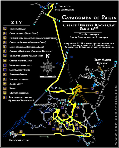
how to visit paris catacombs ? - visiting paris catacombs museum - About two kilometres of the passages are open to the public - the way is marked with spotlights and the walk takes around 45 minutes. The rest is a vast network of underground passages where you wouldn't like to get lost unaccompanied, so don't leave the path! Take a coat with you even in summer, as the temperature is quite chilly underground and if you can, take a pocket lamp... To make your visit more enjoyable, this map-guide will allow you to find most interesting places [ Download catacombs map (printable edition) ]
official websites [exploration maps : see below ]
Underneath Paris The Parisian underground tunnels form a maze of several hundred kilometres. Among these one can count a first level of technical galleries for infrastructure such as communications, gas, and electrical lines. Deeper down are the long tunnels of the subway lines and RER (rapid-transit rail system) as well as the sewage system. About 20m below the surface, a labyrinth of much more ancient galleries exists. This one extends for several hundred kilometres, fully dug in the rock, following the limestone deposits mined from the subsoil of the capital. This is the network of ancient underground quarries under Paris, also known as the catacombs, so named because of the ossuaries that were created in parts of the network, long ago…
Mining of construction stone It has been said that there were once more than 600km of galleries that stretched under the streets of Paris. One can find stone mining remains from Roman and medieval times at the surface level. To find the best deposits formed by harder rocks, the mining descended from the surface deep underground, to slowly extend, from gallery to gallery, an anarchic network of access tunnels. The dug ground began to weaken the foundations of the buildings at the surface and many collapses occurred. The quarry inspection department (Inspection des Carrières, or IdC) was born, which had the effect of banning mining in those areas deemed too dangerous. The department put considerable effort into the building of a reinforced network of galleries directly below the streets and buildings. This is the network of underground quarries we know today.
The dawn of cartography One can imagine that the creation of the first maps dates back to the period in which the extensive expansion of the network made maps necessary in order to find exit points from the underground. Early quarrymen probably drew up the first sketches of maps, using coal to mark the walls. These sketches were probably reproduced for mining needs, but no remains can be found. Some religious orders, particularly the Carthusian monks, used these underground galleries to extract the rock used to build their monuments. It’s likely that they also created some sort of map to suit their purposes. But it wouldn’t be until 1777 and the creation of the Quarry Inspection Department that a strong cartographic drive would systematically map the underground.
The IdC plates Acting on King Louis XVI’s orders, teams of quarry inspectors explore these underground cavities, dig wells, inspect the galleries, test drill in unexplored parts and build stonework. They write everything down, identifying each of their works by creating a system of numbered plates, showing street names, relevant surface monuments as well as the different exits. Over the years, the teams change and continue this extensive work that will be the source of the plans they will create: the inspection (or IdC) plates. The complete collection of these plates is an invaluable inventory of the underground quarries, gathered together as the Paris Underground Quarry Atlas.
The Paris Underground Quarry Atlas. n 1870, during the "Commune", this atlas is requisitioned and put into the Hôtel de Ville (town hall), which would burn the same year. A century of work would be irreparably destroyed during this catastrophe. All record of buried, collapsed or non-explorable galleries that were listed in this precious document would disappear in the fire. A new atlas, to be recreated, updated and improved, is ordered. The resulting plates, which are still being updated, remain invaluable, giving information about the nature of the Parisian (and surrounding region’s) underground.
War maps during the XXth Century The story of the underground does not stop here. Human nature is such that it seeks out the most secret of places, propelled by need, curiosity or the thirst for adventure. During the XXth Century, the underground galleries will encounter a new kind of visitor during the occupation and will be used for the storage of goods and as transit places for the black market. The Germans understand immediately the obvious strategic importance of the underground, drawing a very complete map of these spaces in occupied territory. The Resistance will do the same and will find refuge in underground cavities. Under Paris, the quarries take on a particular strategic importance, making it important to find a utilitarian map in order to stage secretive actions
The mysterious Dr Morel During this period (around 1940), two explorers will seek adventure in the Paris underground. From Saint-Anne hospital where they practice, René Suttel and Jean Tallairach will make their underground incursions night after night. Their need to draw up a reliable map allowing them to find their way easily in this underground maze leads to the creation of several plates which will be continuously updated. During the occupation, they will be contacted by a mysterious figure calling himself Dr Morel. Morel is seeking a map of the underground galleries. This man would later turn out to be the colonel Roy Tanguy; who will make use of these maps to set up the HQ of the FFI (Resistance forces operating in France during the Second World War) and launch the liberation of the capital.
Preliminary sketches of the Cataphile maps During the 60s and 70s, the first clandestine visitors step into these galleries, guided by students from the Universities of Law, Pharmacy, Medicine and the Grande École of Mining Studies. These last ones possess full documentation of the underground that will help them to build the first “Cataphile” maps. Then, just as today, there is a need to have a reliable map system which allows one to wander the complex network formed by hundreds of kilometres of galleries. These maps will be improved with new information about the underground’s places, rooms, curiosities, and, over the course of many years, with info about the access points, blockages, and inaccessible parts of the network.
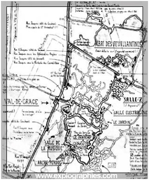
The different plates demonstrate the diversity inherent in underground cartography. This excerpt of the North of the Val de Grâce area (in various forms) shows the numerous shapes the same map has taken during its many evolutions.
Precision of underground cartography The existence of a complete and perfectly precise map seems at best to be wishful thinking. This justifies the presence of inaccuracies or mistakes on these maps, also on the maps drawn by the IdC itself. Four sectors seem to stand against the achievement of a perfect cartography: the Val de Grâce, formed of ‘turned pillar’ quarries partly filled in, the municipal ossuary (the Paris Catacombs) partly inaccessible to the public, Montsouris, whose low and sinuous maze of galleries seems to defy precise renderings, and the Ossuaries, a vast area split into two linked levels. The mapping of a filled in sector quickly becomes subjective: in other words, one can wonder from which height a gallery is accessible, explorable or can be regarded as impassable. From individual interpretations flow drawings that will either show mistakes or accuracies. From this accuracy the readability of a map will shift: it will lose in clarity while gaining in precision. One could show all the level curves and give a highly precise drawing of all the sign plates, but one would end up with an incomprehensible map or at the very least, a relatively unreadable one, except in very large format.
Topographies and Plans by [cube] The plates put forward on this site are no exceptions to the problematic outlined above. They have their own particularities, omissions and even “mistakes”. The creation of these plans aims to draw up an inventory of the inscriptions and the underground sign plates; that is why a more compact version has been used in order to draw up, in the most representative areas, a nearly complete list of these features. These works have been based on the collectivity of pre-existing maps, vectorized into layers to get the overlay of the existing and known drawings of the underground quarries. The nomenclature format established by the Munier-Giraud-Lafouine maps have been kept for the sake of simplicity. Subsequent maps have allowed only for keeping a single drawing and adding historical or topographical information. The assembled map does not feature all aspects of previous works for reasons of readability. In the end, this plate is similar to the wire drawn maps (showing the network in its entirety), using information of the IdC maps, elements of the Giraud-Lafouine and the presentation style of the [cube] maps. On the other hand, some elements have not been kept: for readability reasons, mass and consolidation distinctions (IdC plates) as well as street drawings have been left out. Information about access wells, mostly closed, sealed or covered (which are of limited interest to users), as well as any indication of usable entry points have been removed from these plates.
|
![]()
![]()
Exclusive maps - Latest versions
Posters (extra large editions)
|
|
|
|
|
Paris Catacombs map -The Geological Map-
|
Paris Catacombs map - v.5 international edition -
|
![]()
Other versions available on french main page
Maps, Artworks,
Texts, copyrighted
.
All rights reserved - Reproduction, Publication & Saleare strictly forbidden
.
![]()
-Advanced Maps
![]() Special maps-
Special maps-
 |
|
|
|
|
|
|||||
|
Montsouris Maze |
|
Ossuary Roundabout |
|
Val de grâce Quarries |
|
Catacombs Museum area |
Sarrette South quarter |
|
Bunker Quarries |
|
|
More maps... [encyclopaedia] |
Warning ! Accessing these underground galleries is forbidden by the French legislation. (see below) Trespassing and circulating into these places can be punished by high fines. The exploration of these galleries present lot of dangers. Having a map is not enough to avoid them all. These hazards can even be fatal, caused by wells, due to falling of persons or objects. Hazards of collapses caused by carelessness or by ignorance of the places. Lighting an open fire can be fatal. Trespassing into a quarry put you inevitably in serious trouble possibly leading to severe complications due to the inaccessibility of possible rescuers.
These quarries are also part of our underground heritage. These places are fragile. They contain a lot of historical or geological remains, ancient writings and signs that must be protected. Respect these places. Do not leave garbage in the galleries, do not pollute these locations by paintings. |
|
|
|
Order of November 2, 1955 Art.1: Except for those who are provided with a license by the General Inspector of the Quarries, it is strictly forbidden to enter all quarries which come under the jurisdiction of the Public Roads Department of the City of Paris. This prohibition applies to - opening of doors, trap-doors, stairs and rungs leading into the spaces of the former quarries under the streets of Paris. Art.2.: fines in the present order will be assessed by report of the chief constables and the other officers of the Criminal Investigation Department and the agents of the General Inspection of Quarries having authority to make a report. Art.3. The director of the municipal police and the Engineer General of Mines, Inspector General of the Quarries of the Seine are charged with the execution of the present order which will be archived in the collection of administrative acts and posted in Paris. |
![]()
![]()
- index -
|
|
|||||||||||
|
|
|
|
|
|
|
|
|
|
|
|
|
|
|
|||||||||||
|
cartography |
|||||||||||
conception realisation maps & documents
![]()
© explographies.com
Maps, Artworks,
Texts, copyrighted
.
All rights reserved - Reproduction, Publication & Saleare strictly forbidden
.
Translation : Lisa Hale & Sylvain Margaine
www.urbanexploration.ca
www.forbidden-places.be
Thanks to
Hibou
[top]
![]()
![]()